Homepage
Twitter
Instagram
Email
NiteMode
DayMode
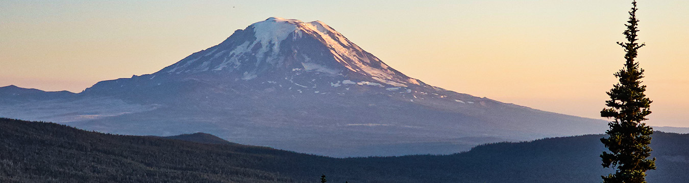
Pacific Crest Trail 2013

I first hiked the Pacific Crest Trail over the course of 1994 and 1996, then I hiked the whole thing in one go in 2013. During the latter hike I kept this website updated as I progressed up the trail. I still have about 45 hours of video to edit, but in the meantime there is a lot for you to look at here. Over the course of the 168 days I wrote 138,734 words and put 13,644 photos on this website.

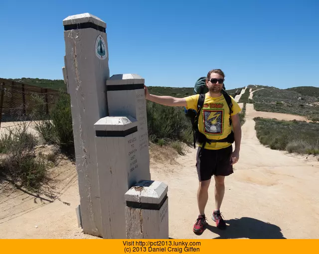
April 17th, 2013 - 12:25pm
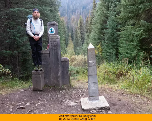
September 25th, 2013 - 5:05pm
July 14th, 2013
day-89_near-crystal-lake-fish-hatchery-to-burney-falls-state-park
CaliforniaNear Crystal Lake Fish Hatchery to Burney Falls State Park
19.75 km today
2290.9 km total
12.27 mi today
1423.50 mi total
20130925 20130922 20130919 20130916 20130911 20130902 20130901 20130830 20130827 20130824 20130821 20130820 20130814 20130814 20130813 20130811 20130808 20130808 20130807 20130805 20130802 20130802 20130802 20130731 20130731 20130729 20130726 20130722 20130721 20130718 20130714 20130711 20130710 20130708 20130707 20130704 20130701 20130626 20130623 20130622 20130619 20130617 20130614 20130613 20130610 20130604 20130602 20130530 20130526 20130523 20130521 20130517 20130516 20130512 20130511 20130509 20130507 20130502 20130428 20130426 20130424 20130422 20130417 Pacific Crest Trail Map

Since I camped after dark last night, today I got to wake up and play the game of "what did I camp near?"

The answer was some sort of horse/cattle loading ramp and a house. The house looked like it belonged to the power company.

Since I was up late last night, I slept in and didn't get onto the trail until around 8:00am. I thought I might be able to make it past Burney Falls State Park today (12 miles), but I had a major worthy off-trail distraction to take photos of today...so I knew it probably wouldn't happen.

The 1996 photo I had of the first creek after Hat Creek Rim, didn't look anything like what the creek looked like now. After getting to the power plant I realized that the creek must have been it so I walked the .2 miles back to the creek. The same tree was there after all, just the area is very overgrown now.

There were a ton of people fishing the water where the power plant dumps out its water. People were perched up on the steep sloping concrete walls trying to get the best spot. This area has changed a bit since I was here. The road bridge is now gone and there is a pedestrian bridge. The pedestrian bridge (where the trail crosses) was chock full of people and lawn chairs.

Crossing the little bridge felt like the opening scene in The Jazz Singer (the Neil Diamond remake). People of all shapes and sizes and races were all after the same fish, using the same intensity and skill.

The fish hatchery had a little picnic area so I made breakfast and did the charge/dry cycle. (charge phone, dry sleeping bag)

The trail stayed flat and eventually I came upon some trail magic after one of the road crossings. Here were two nice reclining lawn chairs, the newspaper from two days ago, a bunch of cereal, and some candy bars/drinks in the cool. I spent some time there and eventually a golf cart pulled up. It was the two people Randy and Kathy (and their dog Bandit) who maintain it. Turns out they live a stones' throw away.

The trail stayed flat and eventually it crossed what used to be a rail line. In my 1996 photo the tracks are still there, but now they are gone. I found out via the Internet that the tracks were pulled up around 2007.

I continued down the trail another couple of miles and eventually I got to a spot on the trail where it turned south that I've been wanting to get to for quite some time. Part of the reason I'm doing the hike this year is because of this spot...mostly because in 1996 I didn't know I was so close to it.

I cut off the trail to the north and it went steeply downhill. It was really hot out and crossing the steep lava rock fields was quite miserable. Eventually I could see the road (which used to be the rail line) right below me, but there was no safe way of getting to it. Just up from it I could see my destination. I had to cut uphill and over a bit more. There was the remains of an old road that led down to the former rail line.

I rounded the corner and there it was, a railroad bridge, now blocked off by some large blocks of concrete and barbed wire fence. This wasn't just any rail bridge. You know that scene in the 1985 movie "Stand By Me" when Gordy and Vern are crossing the rail bridge and the train comes? This is THAT bridge.

It looks remarkably the same in 2013. The only main difference is that the tracks are now gone. The sloped area in the background is now overgrown since they are no longer maintaining the rail line obviously.

The sun was baking hot and bright. I took a few photos of the area where they are all debating about crossing the bridge.

Although it was blocked off, there were no signs about staying off the bridge. I grabbed onto the fence and swooped around the barbed wire Illinois Jones style. After taking a bunch more video and photos I decided I had to cross the bridge. I didn't have a comb with me but I did grab a pine cone (since it is more natural, easily available, and rhymes with "comb") that I could drop off the bridge; just like Vern did in the movie.

There were a few boaters moving about on the lake below. I'm not sure how high the bridge is (no net available as I type this) but it warrants all caps on the words HIGH and LONG. When they are running in the movie, they really are running for quite some time. In the commentary track for the movie they say that in the scene when they are running from the trail, it was shot from a telephoto lens...as to flatten everything out and make it look like the train is really close to them.

The bridge trestles were in decent shape overall, only a few were rotted out. Those I just skipped over. I tried not to think about the fact that I was very high up. Since I had so much recent practice on wobbly rock hopping in the sierras, firm bridge trestles didn't worry me too much. I didn't go anywhere near the sides of the bridge...I could feel the vertigo/high anxiety if I got close to them. The bridge was wide enough so if I did fall sideways I wouldn't go anywhere.

Walking over the bridge I could see all the repair thay had done to it over the years. Steel plate here, more wood there, and banding straps around several ties.

Some graffiti person had made a design at each end of the bridge and on one of the reinforcement plates, "Stand By Me" in a nice font was written below it.

On the way back I remembered the pine comb. There were some boaters below so I decided to wait and drop it on the other side. When I did stop in the center of the bridge I felt a bit of panic, so I just kept moving and remembering to breathe. I think this is why kids get horribly drunk when they do stupid stuff like this so they don't et these feelings.

After crossing the bridge again I looked at the video. I had the camera on the wrong side and the shadows were messing stuff up. So I had to do it all over again! I ended up going across the bridge about six times. It did get easier each time.

Finally after spending about three hours there I had to get going. I was out of water and had to get to the Burney Falls Store before they closed at 8:00pm. Just after the bridge in the dirt I found a piece of metal that obviously was part of the railroad. I stashed it in the dirt and marked the GPS coordinates so I could come get it later.

I went up the hill through the brush and eventually got back to the PCT. It was a pretty fast walk to the state park. Someone had left a plastic folder bag on a tree with a note reading "leave a note for a thru-hiker behind you". I thought that was a nice idea. Of course...I didn't have time to leave a note.

Got to the General Store at the State Park around 7pm. A thru-hiker I hadn't met yet named Tracks was there. I went inside and saw the guy from Scotland who I had hiked with in that rainstorm.

I saw the words "Root Beer Float: $3.50" on the board and ordered one of those. My box made it ok. Got some beer (clerk had to do the "I am not old enough to sell beer shuffle" with the other clerk...this means he was just a baby when I first hiked the PCT, ugh) and went outside to unpack my box and have a good PCTBS session.

The guy from Scotland had received new shoes, size 15. Some hiker told him they know where he is at since he seems to have the largest feet of all the PCT hikers.

He and Tracks also told me about the rattlesnakes they saw on the Hat Creek Rim. I fully expected to see at least one but never did. I did in 1996 though.

It is about 9:35 now and getting dark. I'm charging camera batteries and my phone courtesy of the bathroom and general store. My battery pack will not charge, either it is messed up or the USB cable is hosed.

Debating about getting up early and hiking the two miles back to the bridge to retake video/photos early in the morning before the light gets all messed up. If I can wake up in time I will, if not I shall hike onward.

Ok, more on that night...

After I finished up that last bit I packed up and went to look for Godfather (guy from Scotland) and Tracks. The area for PCT hikers was somewhere behind campsites 81 and 83. Eventually I found the area but couldn't tell where they were in the dark. Turned around and went to take a shower.

I only had two quarters which was good for five minutes of water. No money, no water (not even cold). Because of this, I had to count up to 300 hundred as to not find myself covered in soap at 10:30pm with no easy way of getting it off. Dried off with my polypro thermal since it was the only thing clean I had that resembled a towel.

I figured I would go camp somewhere near the trail so I went to fill up my water bladders. While it was filling I was trying to figure out what time I should get up so I could walk back to the bridge and get there before the sun was up. All of the sudden it hit me, I could just camp next to the bridge. Matter of fact, I could camp where all four of them in Stand By Me were arguing if they should cross the train bridge or not. Despite it being a Johnny Sixbeers Andnodinner idea, I was really excited to do it.

This was the first time I think I walked southbound on the PCT for a reason other than I had forgotten something.

I munched on the bag of Corn Pops for the next hour. At one point the trail crossed a dirt road and I lost it for a bit. The GPS got me back to the trail, crashing through the sticks and weeds, but I got back to it.

I got to where the cutoff was and found an overgrown logging road that looked like it headed down to where the rail line used to be. I followed it until a giant tree had fallen over the road. There was no way under/over it so I followed the very large tree up the hill. By the time I got to a point where I could get over the tree I was back on the PCT again. Argh. I ended up just following the PCT another 1/2 mile until the turnoff for Rim of the Lake spring was. I hadn't been down that way but it was a road and I was guessing it would eventually lead to the rail line.

Halfway down the road was the spring, I had never seen so much water come gushing out of the side of a hill. After going through some brush the trail did eventually end up on the rail line. I followed the rail line and eventually there was the bridge.

I was in a bit of a dilemma as to whether or not to put my tent up. It would make for such a better photo if my tent was perched at the head of the bridge...so that is what I did.

About 1:00am I grabbed my phone, headlamp, then walked out onto the bridge. I went out pretty far (around the spot where Vern falls down in the movie) and laid down on the rail ties. The water was below me and the stars were above. About every minute I would see a shooting star. It was quite unnerving laying there at 1:00am. I felt as if I was going to either fall forwards into the sky or backwards 100 feet down into the water. There was only one thing left to do....put on Frankie Teardrop.

The whole experience was by far the most surreal/spooky thing I have done on the trail. When the screams in the song came through the headphones I felt a little nauseous. I knew I couldn't really fall off the bridge, but the thought of getting mentally stuck out there was really unnerving.

After the song ended I got up and started to walk back across the bridge. It was a bit hard getting my feet confident enough to move and follow my headlamp beam, but I made it back to my tent and went to sleep for a whopping four hours.

I shot all kinds of video of the bridge but since I'm hiking at the moment...it will have to wait until I get home to find its way online.

Here is a news article about the bridge.

Be sure to check out the 7/15 entry for more bridge photos.


The scene in the 1986 movie "Stand By Me":

The Train Scene from the movie "Stand By Me"


Bridge in relation to the PCT:

The easiest way to get to the rail line from the PCT is to take the Rim of the Lake Spring trail all the way down to the abandoned rail line. Map


Then: Side view of bridge.Stand By Me Bridge

Now: Didn't have access to a boom crane, so this is the best I could do.Stand By Me Bridge


Then: Looking North where they argue over crossing the bridge.Stand By Me

Now: I had no argument against camping in that same spot.Stand By Me Bridge


 Then: Looking South.Stand By Me Bridge - South

Now: Much more overgrown.Stand By Me Bridge


Then. Crossing the bridge.Stand By Me Bridge

Now: Boaters in the shot!Stand By Me Bridge


Then: Looking south.Stand By Me Bridge

Stand By Me Bridge

Now: They obviously don't do maintenance anymore on the train line.Stand By Me Bridge

Stand By Me Bridge


Then: Shot of the hillside.Stand By Me Bridge

Now: The dead trees have decomposed.Stand By Me Bridge


Then: Looking North.Stand By Me Bridge

Now: Looking North.Stand By Me Bridge

Then: Corey Feldman and River PhoenixStand By Me Bridge

Now: Not available and RIP. :(


Then: The Jump.Stand By Me Bridge

Now: More decoration via spray paint.Stand By Me Bridge


Then: Landing Spot.Stand By Me Bridge


Now: More weeds.Stand By Me Bridge

July 14th, 2013
19.75km
12.27mi