Homepage
Instagram
Email
NiteMode
DayMode
Pacific Crest Trail 2013

I first hiked the Pacific Crest Trail over the course of 1994 and 1996, then I hiked the whole thing in one go in 2013. During the latter hike I kept this website updated as I progressed up the trail. I still have about 45 hours of video to edit, but in the meantime there is a lot for you to look at here. Over the course of the 168 days I wrote 138,734 words and put 13,644 photos on this website.

April 17th, 2013 - 12:25pm
September 25th, 2013 - 5:05pm
September 25th, 2013
day-162_hopkins-lake-to-usa-canada-border
WashingtonHopkins Lake to USA/Canada Border
10.1 km today
4281.01 km total
6.27 mi today
2660.10 mi total
20130925 20130922 20130919 20130916 20130911 20130902 20130901 20130830 20130827 20130824 20130821 20130820 20130814 20130814 20130813 20130811 20130808 20130808 20130807 20130805 20130802 20130802 20130802 20130731 20130731 20130729 20130726 20130722 20130721 20130718 20130714 20130711 20130710 20130708 20130707 20130704 20130701 20130626 20130623 20130622 20130619 20130617 20130614 20130613 20130610 20130604 20130602 20130530 20130526 20130523 20130521 20130517 20130516 20130512 20130511 20130509 20130507 20130502 20130428 20130426 20130424 20130422 20130417 Pacific Crest Trail Map

Day 162: USA/Canada Border [mp 2660.10]

Spoiler alert: I made it!

It was pretty odd this morning waking up and being in no hurry to get anywhere. I was not meeting Cora until 4pm, a whopping 6.3 miles away.

Rabbit Stick came by for our (sadly last) morning hot chocolate. He was going to head on out after getting to the border, but hoped to see Cora and I at 10am the next morning. I wrote out a note for him to pass onto Cora when he saw her.

I started reading Slaughterhouse Five which I got from the post office at Stehekin. Even in the first few pages I started seeing all of these pop culture references. There was a reference to the "Children's Crusade" and I remembered how one of the early tours of the USA that Husker Du did was called the "Children's Crusade Tour". (Granted I was about eight or nine when this tour happened, but that is beside the point).

Spent a long while drying my socks out over the Jetboil stove. I was able to get them from sopping wet to soggy wet. My feet went numb after I put the socks on. Right about noon I headed out onto the trail.

Stopped a few times to get some time lapse video of the clouds going by. Somehow I knew in the back of my mind that I would still be rushing to get to the border even though I had all day to get there. I have a great skill in burning up an entire day to reach a given point. If I only have to go five or forty miles in a day...it can take me all day to get there.

I have a photo from 1994 of me standing about five miles from the border, holding up a handwritten sign that read: "..Till a sign said 'Canadian Border five miles from here' - Bruce Springsteen". It is a lyric from the song Joe Roberts off his excellent (and best) 1982 album "Nebraska" (to which the song was later used as the basis for the Sean Penn movie 'The Indian Runner' ).

I checked my GPS app and saw that I had actually gone a little bit past the five mile mark. Since I had time (and had to get working on burning up the day) I walked southbound for a few minutes until I got to the spot on the trail where the Canadian border was actually five miles away. Right after reaching the spot I saw a northbound hiker heading my way. We said hello to each other, I think his name was Tyler. He had hiked most of the trail in 2003 but had to stop around Glacier Peak. So now eight years later he was finishing up the last bit of trail he had to do. I told him my plans and he seemed pretty confused at how I was going to meet Cora at the border, yet I was hiking south. I laughed and told him about trying to find the spot on the trail that was five miles from the border and how I had overshot the mark and was walking southbound for 1/4 mile. As we were talking we saw (drawing a blank, the couple with the two husky dogs), they had hit the border yesterday. They camped at the border and were headed south back to Hart's Pass where someone was going to meet them and drive them out. They had wondered where I was since they thought I would have been done by now. I told them I was taking a couple extra weeks to do Washington since it is one of the best spots on the trail.

After he left I set up my tripod and took a few photos. I started back down the trail (northbound!) and started looking for the tree that I was standing next to in my 1994 photo. In that photo I was posing next to a tree at a spot I guessed was about five miles from the US/Canadian border. I was hiking with Pete Fish then and he had taken the photo.

The tree had a scar on the bottom that looked like an inverted "P" that was filled in. I walked for a while and there it was, the tree! I took the phone out of airplane mode and saw that I was at 4.9 miles from the border, my "this is 1994 and GPS's are hard to come by so I have to guess" guess was only a tenth of a mile off!

I started to prep stuff for the photo but knew I was going to have trouble reproducing the angle since Pete was holding the camera at a height around two feet higher than my tripod would go. Before I had a chance to figure out what to do...Storytime (the younger one) appeared. I congratulated him on finishing. He was redoing the whole trail this year because he took a bit too long last year and got stuck in snow once he hit mid Washington. He took the photo of me holding the sign and was pretty excited that it came out pretty close to the original. It took me a bit of time to reproduce the same 1994 issue frown that I was sporting back then. We bid each other goodbye and I continued north.

As I walked I decided I needed to overthink something, so I spent a good 20 minutes figuring out what clothes I should wear crossing the border. Most of the time was spent figuring if I should wear my baseball cap I had been wearing the entire time, or the more practical (since it was cold) stocking cap.

Had to take my last phone call holding on line two. I hate to say it but it felt a little ceremonial and I am quite uncertain what international rates are. Time will tell.

Got to Castle Pass and had a look around. Saw the trail to Ross Lake which made me think of kayaking with Dad in 2006. We saw the other end of the trail at Ross Lake near where we camped one night. Started down the trail and realized I hadn't wasted enough time so I walked back up to the pass to get a couple more photos and eat some stale Cheetos. They made my beard a complete mess. Gotta pretty that shit up for Cora son.

As I was standing there I saw a guy and girl come up the trail. I said hello and I recognized the guy but couldn't place him. He introduced himself as "Wabash". Her name was Lakeview/Callie (sp? never got the correct spelling).

We then acknowledged that we recognized each other. It was Casey, who I had last seen hiking with Colin clear back near Idyllwild, almost 2500 miles ago! I think he broke the distance record for the time I had last seen someone I knew on the trail. Colin I had later seen at Shelter Cove in Oregon. We talked a bit and I ended up hiking with them for a bit. They stopped for a break and I continued on. They too were planning on camping at the border so I told them I would see them at the border, or before if I needed to stall some more. I didn't want to get to the border before 4pm. I told Cora I would get there right at 4pm and was holding to it.

I watched the distance click down on the Halfmile PCT GPS app. Finally I hit the point where I was exactly one mile from the border. At that point I did exactly what anyone would do who drove a Camaro to High School in 1990 would do, I put on the song "The Last Mile" by the hair metal band Cinderella. (on a side note, their album 1991 Sticky- Fingers sounding album "Heartbreak Station" still holds up pretty well even if the rest of their catalog sounds extremely dated).

Just as I was getting into the song the ipod shutoff. Argh! I thought to myself this morning I should have really charged it up while I was reading in the tent...just so this would not happen. So being myself I walked back up to the start of the last mile spot, dropped my pack, and got out my external USB battery. Since I had the pack torn apart I decided I was gonna stay true to form and wear the baseball hat across the border.

As I was doing this Wabash and Callie (STBPC - Spelling to be possibly corrected) came on by. I did out the math and figured I would be hitting the border right around 4pm.

The Cinderella song ended. I was so distracted without thinking about the end of the trail that I couldn't really get into the song, so yes, I played it again. It ended and some God-awful song with a cowbell intro came on. Now I had even more problems, I had to get that cowbell out of my head. (I know you are reading this thinking: 'Seriously Craig?'). I put on Townes Van Zandt's "If I Needed You" and it was soothing.

I wasn't going to listen to anything after that, but since I was going to be seeing Cora at the border I should listen to the most emotionally impacting song I could think of...one of the two songs Cora and I played at our wedding. I didn't have Tom Petty's "Here Comes my Girl" so I had to choose the one I did have, which is also the one that goes for the metaphorical throat, Spiritualized's "Ladies and Gentlemen We are Floating in Space".

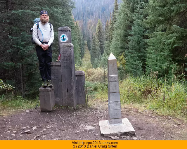
I walked down the trail getting slightly emotional thinking about the end of the trail and seeing Cora. A few steps farther and there it was...the first of the four switchbacks. Just prior to the border are four switchbacks/sharp turns in the trail. I heard Wabash and Callie cheering down below in the trees where the monument/border was. I could see the border from where I was standing. Really, you can see the border because they have clearcut the trees about 25 feet wide where the border is at.

Right at 4pm I went around the first switchback and I recorded video during the walk down. I counted down each switchback as I went around it:

4, 3, 2, 1

I came around the last turn and could see the monument. Wabash and Callie were sitting at the base of it. I started running a bit and got to where the clearcut was.

I looked ahead, left, and right...no Cora.

I stood there for a bit in a slight daze since I was thrown off a bit since the image I had in my head of the finish was not matching up with reality. Callie looked at me and said "Sorry....we are the only ones here".

Wabash and Callie looked through the register. The metal monument comes apart and inside is a ziplock bag with a notebook in it. As they looked through all the entries in the register I sat on the USA side of the border figuring out my next move. I figured I would just wait there for three hours until it got dark and then go from there. I had no cell service so calling was not an option.

I sat there a little sad that Cora was not there. Mostly I was just kind of in a daze that I was done with the trail, yet I was incredibly indifferent about it. (later someone described the feeling as the one you get when you shut off a light, walk out of a room, and not remember what just happened.) I should have been jumping around but I kind of just sat there eating some stale knockoff Lucky Charms cereal.

Callie made a joke about me being stood up and I laughed. I said that I was still going to crack open the beer I packed from Stehekin at 5:00pm regardless.

Wabash retook the photo of me at the monument in 1994. Earlier in the hike I joked at how I might have a hard time reproducing the frown I had in the photo, but sadly I missed Cora so I had that same frown now when he took the photo. (audience cue: "awwwwwww"). I looked at the photo he took and noticed that the point of the monument was not lining up with the clearcut trees. I asked if we could retake it again since the monument was not lining up. "Oh man, I never even noticed that the border is physically cut into the trees until now, I thought it was just an open field we were in!", Wabash said. We retook the photo and got it pretty close.

Callie and Wabash headed off to the campsite 1/4 mile (oops, this is Canada now, .402 km) away.

I cracked my beer open around 5:30pm. I took the mileage photo of me holding up "2660" with the clock cardboard. I took a few other photos of me at the border. I cursed as I realized I hadn't had Wabash take any photos of me with my iphone (which meant I could't put anything online until I got home).

About five minutes later I heard something off in the trees and could see someone walking. I knew it had to be Cora! "watch her walk" popped up into my head as she came around the corner. (That is a Tom Petty "Here Comes My Girl reference..something I never really heard in the song until my friend Molly from Yakima pointed it out to me in 1992 when we used to quiz each other on song lyric knowledge via Red Robin coasters (where we both worked))

I turned my camera on and it was me who was cheering the arrival at the border. "Congrats on walking the entire Canadian PCT!!", I said to Cora.

We briefly kissed and hugged, (not to get into gross TMI-land, but this huge beard really prevents any sort of Harlequin Romance level of passionate kissing). She was holding the note from Wabash and Callie that I had given her. She told me about running into Rabbit Stick and getting the note from him too.

(Mom, TMI means "Too Much Information)

We ended up spending a while there taking pictures and video. Cora had brought some canned champagne. ("lighter than beer!", she said).

It was starting to get cold and dark so we made our way to the campsite (.402 km away in case you forgot).

Wabash and Callie cheered as we entered camp. We all spent the night chatting and drinking the canned sparkling wine.

Tomorrow Cora and I walk out. Wabash and Callie are going to catch a ride with us to Vancouver. Funny how I had last week Wabash near Idyllwild and now he was going to be riding out of Manning Park with US. Never could have predicted that.

Here is a video of me reaching the border and meeting Cora:

2013 Pacific Crest Trail Finish

September 25th, 2013
10.1km
6.27mi